Introduction and Brief History of BC Rail
On 27-Feb-1912, the Pacific Great Eastern was incorporated, and with it, one of the most fascinating yet obscure railways in North America was born. By 1915, the line linked Squamish and Lillooet, and then pressed on towards Quesnel with its eventual goal of linking Vancouver with Prince George and the interior. Williams Lake was reached in the fall of 1919, with the line completed into Quesnel by early 1921. Despite such good progress through the incredibly remote and rugged terrain, progress stopped just north of Quesnel at the Cottonwood River crossing. Due to the inability to find a stable site for the bridge, Quesnel became the de facto terminus of the line for nearly three decades. The trackage laid north from Quesnel and south of Prince George would be torn up in the 1930s, and at this point the line would founder.
However, in the 1950s, provincial politics once again pushed it foward, with the Quesnel-Prince George segment completed in 1952. With the arrival of the politics of Premier WAC Bennet in 1952, the idea of a railway opening British Columbia was once again in the spotlight. An infusion of government investment made the difficult Squamish-Vancouver link along the Howe Sound possible by 1956. Looking at the unopened north, plans for the railroad to be extended beyond Prince George were dreamed up. By 1958, the PGE linked North Vancouver with such northern points as Chetwynd, Fort St. John, and Dawson Creek (at the Northern Alberta Railway). At this point, the railway would once again stop building, if at least for a few years pause.
By 1971, the two last great reaches into the wilderness were underway – one of which would become the Fort Nelson Sub and the other the somewhat infamous Dease Lake Extension. The Fort Nelson Sub, linking Fort St. John with its namesake petroleum-rich boomtown on the Alaska Highway, was completed in 1971. The Dease Lake Extension, however, was built on a far more speculative basis. Following the Rocky Mountain Trench, the line was started at Odell in 1967 to originally connect Fort St. James. However, thinking in a grand manner, after the line reached Fort St. James in late 1968, the province decided to build a line into the upper reaches of nowhere, expected to end at Dease Lake – little more than a random inkblot on the provincial map. The intention was always that this would be the railway link from the lower continent to the Alaska Railroad. However, since it was speculative construction without any real customers, the BC government stopped the rails at Chipmunk in 1977, several hundred miles short of the end of the grade. Also during this period (1972, to be exact), the Pacific Great Eastern became the British Columbia Railway. This would mark the end of BCR’s expansionist era, save one new line.
One final piece wasn’t yet in place, however. Like I mentioned, it’s an odd little railway, and the oddest piece of them all was conceived in 1978 – the Tumbler Ridge Subdivision. Deep in the British Columbia wilderness lay high quality metallurgical coal, near the town of Tumbler Ridge. In 1978, just a year after cost-cutting measures had struck down the Dease Lake extension, the BC government decided to once again extend its railway. Eager to tap the Asian demand for this coal, they proposed a line from Tacheeda to Tumber Ridge and eventually Quintette. However, due to the terrain (and tunnels) it would be traversing as well as some political influences, the engineers chose to electrify the line using power from some of the large provincial hydroelectric projects. With its 50kV AC electrification and six unique EMD GF6C electric motors, the 82 mile route was truly an engineering marvel and railroad oddity in North America. Completed in 1983, it would also be the first shut down. On 29-Sep-2000, the GF6Cs dropped their pantographs, probably forever, and the overhead was turned off. Diesels continued to operate the line until 10-Apr-2003, when the last train left the Bullmoose Mine, and at that point the line was mothballed.
To me, the first sign of trouble came in mid-December 2001, when BC Rail announced that it was exiting the intermodal business, stating that it was losing money. Nearly every other railroad on the continent is successfully trying to capture intermodal traffic, and here’s one that’s well suited (there really are no high-speed road links from Vancouver to Fort Nelson or the other northern points) that’s trying to dump service. Shortly after that, the announcement came that the current BC Liberal administration, led by Gordon Campbell, introduced and passed legislation allowing BC Rail out of its traditional passenger-carrying obligations. This was after an election where Campbell had promised that the BC Liberals “will not privatize or sell BC Rail”. I don’t pretend to understand the politics of BC – the parties, the issues, the elected officials, or even the general mindset. However, as an American well versed in double-talking politicians, I can smell a weasel a mile away, and something stinks in Vancouver. Just a year after the introduction of its new luxury train, the Whistler Northwind, it was dumping the whole operation – the dinner train out of North Vancounver, the Whistler Northwind, and the traditional Budd car (and well-patronized) Cariboo Prospector. The final dinner train ran on 21-Oct-2002, and the final Cariboo on 31-Oct-2002.
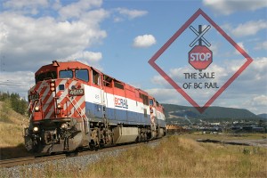
Then, without much warning, the big bomb hit. On 15-May-2003, BC Rail put out an RFP for prospective buyers, signaling the beginning of the end for the Crown corporation. For those interested, the RFP information is available online from BC Rail’s website. As one can clearly see by its history, BC Rail has always been a puppet of politics, seldom building as market forces dictated, but rather being built to help build a province. While the early and unexpected closure of the Tumbler Ridge line had left the railway with a considerable amount of dept, everything I’ve been able to find shows that the railroad is profitable and getting moreso, despite having to service some $600 million in debt and operate through some of the most remote and inhospitable country in all of populated Canada.
The worst part (and this is purely my speculation now) is that I believe this is driven by a two-forked issue: the current government wants to make a quick one-off buck (or should I say, “loony”) to make the provincial budget look good this year, and they want the right-of-way to pave in order to meet capacity needs for the 2010 Olympics in Whistler. CN is often mentioned as the leading bidder for the line, and it’s been admitted that they’ve drawn up a plan for abandoning everything south of Chasm. Since they connect at Prince George and North Vancouver, there’s no reason to operate the costly southernmost 200 miles of the BCR system. This works out conveniently, since the Province needs to build more highway capacity between Vancouver and Whistler to accomodate the 2010 Olympics traffic. The only place to put more lanes between North Vancouver and Squamish is – you guessed it – the BCR roadbed. Oddly convenient, isn’t it? There’s that weasel smell again…
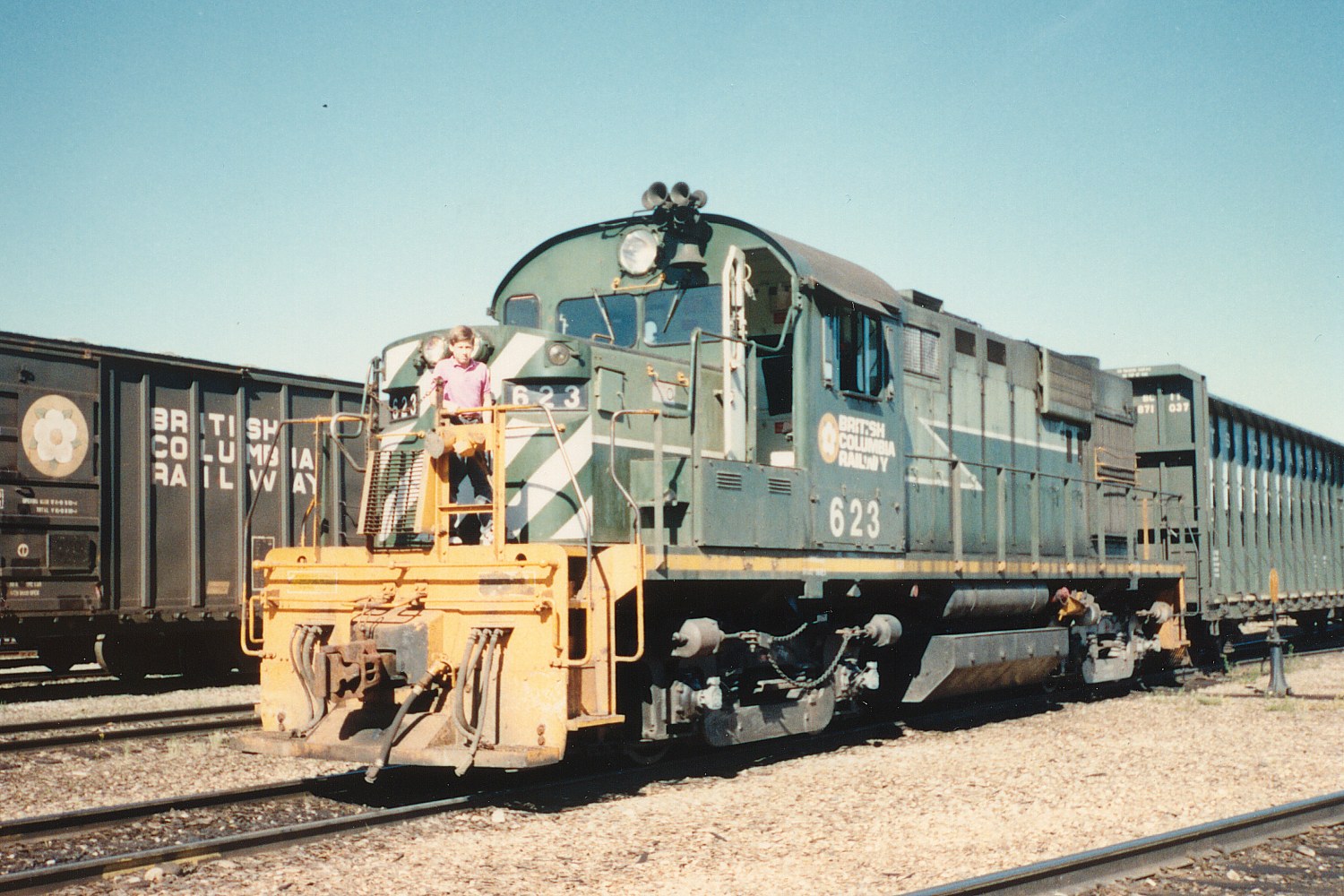
I’ve had a fascination with BC Rail since the late 1988 issue of Pacific Rail News covering BCR’s North End (Chetwynd north and east, basically). Something about four-axled Alcos and other bizarre power running through middle of the BC wilderness always captured my interest and imagination. At the time, I was only 12, and as such obviously couldn’t go see it for myself. As luck would have it, a year after receiving that issue, the family vacation for the summer was to head north to Alaska – by road. With the Alaska Highway starting in Dawson Creek, the route took me right into the heart of BCR’s north end operations. Used to the fan-ambivalent (or fan-hostile) railroads of the US, I was quite surprised when, after photographing the Dawson Creek job (with BCR 643 and 644) switching for a while at Dawson, one of them asked my parents if they could haul me around for a bit. So, my first cab ride – in BCR M420 644 – came about on BCR in one of the units I’d been looking at pictures of for months. Later in the day, again without asking, the yard crew invited up on RS18 623 in the Fort St. John yard. All I need say is that still some of my best memories of railfanning are still about that remote segment of BC Rail, thanks to the great people up there that took time out of their day to make the day of a train-loving kid in an ugly pink shirt. (Photo #1) Yes, that’s really me in 1989 on 623.
Getting There – Aug 22-23, 2003
With the news of the impending selloff of BC Rail, I decided to make one last trip up to see it. My last trip was in Apr-May of 2001, and you can go see that trip report here, if you’re interested. I’d lost the Rio Grande before I really had the ability to go see it in person for any length of time, and now that I had the time, money, and capability, I wasn’t letting my other favorite railroad slip away. So, in the course of two weeks, I put together all the needed pieces and headed out for Vancouver late Friday night (22-Aug-2003).
However, there was no sense wasting the 1600 mile drive each way, so the first night’s stop was Helper, UT. However, before leaving work I’d seen a note from Paul Birkholz that several MRL units (302, 303, 304, and 356)leased to BNSF) were making their way down the Front Range, so I was carefully watching for them as I left work. As luck would have it, I caught up with them in a light power move at Sedalia in what would turn out to be some of the last sunlight for the afternoon. (Photo #2) A nasty storm system was brewing over the mountains, and after leaving Sedalia I’d be fighting periods of intense rain and wind for the next eight hours. The only other train I’d actually see for the rest of the day was a BNSF job (with ATSF 925 and a rebuilt BN GP30, 2806) working the American Soda branch out of Parachute, CO, on the western slope. However, due to cloud cover, I didn’t get any really good shots of it. (Photo #3)
Friday dawned bright and early, but I didn’t. I hadn’t gotten in to the National 9 in Price until after 2300h, so I overslept the alarm by quite a bit. Suspecting that I’d already missed the Saturday dirt train, I headed up to Helper to see if anything else was going on, only to be surprised by the the train in question calling West Maxwell on the radio. In true Rio Grande form, four DRGW tunnel motors were up on the front, even if one did have a severe case of yellowness. Helper always feels good in the morning, partially because it’s nearly always a clear, crisp morning when I’m there, and partially because the old Grande motors are always up and running. Today it was 5349 on the lead, followed by 5371, UP 8620 (ex-DRGW 5363), and DRGW 5390. (Photo #3) I chased the train down as far as Wellington, but with the cloud cover to the south, I eventually gave up. Besides, I hadn’t brought the Yukon on this trip, but rather my Del Sol. I had no particular desire to take a tiny, two-wheel drive car out into the desert the morning after a large rainstorm, due to the danger of getting stuck.
Heading north again, I heard another one call Maxwell – this time the Utah 5006 east. For those that don’t know, the Utah 5000-series units were the six (and only six) MK5000C units ever built. However, about a year ago, all of them were withdrawn from service and sent back to Morrison-Knutsen / MotivePower Industries due to broken crankshafts, bad crank bearings, and/or damaged alternators. After some work, MPI decided to rebuild them with EMD internals (giving up on the big 5000hp Caterpillar engines, believed to have failed due to excessive flex and vibration), and bought 6 ex-UP, ex-MP SD50s for the task. 5005 was the first returned, in the full orange colors of the Utah’s new owners – the Gennessee & Western. Shortly afterwards came Utah 5005, and then later 5002. While they retain their original cab and frame, long hood is now that donated from an SD50, and the internals are mostly EMD variants – a 16-645F3B prime mover and an AR10 alternator, combined with a Q-tron QES-3 control system. As luck would have it, I met 5006 leading the other two and the bizarre MPEX 5000 (SD45 body and frame with an MK5000 cab) on one of the Intermountain Power Project trains at Price. (Photos #4, 5, 6)
Continuing up the hill, the next train didn’t show up until near Gilluly, where Amtrak 6, the eastbound California Zephyr, was passing under the highway as I drove over. I’ve seen 6 a zillion times, and normally it wouldn’t hold that much interest. However, today it was late for some reason, and there was a UP SD70M (4821) tacked on the front. This has apparently become somewhat common as a way to help Amtrak make up time over the former Rio Grande, as this has been reported several times on the DRGW list lately. I drove back up to West Soldier Summit and waited for him, and fortunately the cloud cover decided to cooperate and open up as it approached. (Photo #7)
At that point, I’d blown quite a bit of the morning, and to keep on schedule I decided to skip over looking at anything in the Provo to Odgen area. With all the rail activity, it would have been easy to blow half a day chasing random stuff, but I was determined to get into Vancouver early Sunday afternoon. That would require making good time across Idaho, Oregon, and part of Washington. I actually managed to do it, too, despite seeing some old SP motors while passing through SLC. By early afternoon, I was on I-84 headed out of Utah.
The next train of the day was a loaded UP grain train I spotted near Bliss, ID. Since it was moving along pretty well, I stayed on 84 for a bit and finally got off the freeway near Hammett. Following the line west of town on what my maps show as the Old Oregon Trail Highway, I found a small driveway at the top of the hill, overlooking a broad curve and the valley below. After waiting for what seemed an eternity (but was rather more like 45 minutes), UP 8510 and train finally showed up. (Photo #8) As the end of the train appeared, I realized why it had taken so long to go so few miles – there were now manned helpers at the back of the train, shoving it up the hill. Ever since DPU showed up in force in Colorado, manned helpers are an oddity in my world. It makes me wonder why UP hasn’t started using them through this area, too.
I stopped for dinner in Boise, ID, and drove past the MPI facility on the way out of town. Sitting in the shadows, half buried behind some stuff, was one of the new GP20Ds that MPI is building for Union Pacific under contract from EMD. They’re being leased through CIT Group, and you can read more about it in the press release here. Unfortunately, I couldn’t get a shot of it, or even fully read its number.
I finally wrapped up the day at the Motel 6 in Yakima, WA, putting 1250 of the 1600 miles to Vancouver behind me. I figured the remaining 350 would make for a nice, relaxing drive across the costal ranges and up the coast into Canada. Things are never that easy, though.
I’d logged on to Trainorders from the motel Sunday morning to find that Tacoma Rail would be going all the way out to Morton (on its Mountain Division, a former Milwaukee branchline) to drop off a boxcar. Figuring that might be an interesting thing to see, I headed over to Morton via US 12. When I left Naches, it was a beautiful, warm morning, so I took put the top down on the car. Stupid me – while it was a fun drive up to White Pass, as soon as I crested the summit I was freezing to death from the cold ocean winds. Dumb, dumb, dumb. However, having the top off, I could hear that the bizarre thumping noise I’d been hearing since Utah was indeed growing louder. However, it still wasn’t alarmingly loud or even consistent, just enough to get paranoia worrying types like myself thinking about all the things that could ruin the trip.
Passing through Morton and then driving up towards Tacoma on 7, I never did find the aforementioned Tacoma Rail train. The scanner went off a few times, but never provided enough information to get a good idea of where it currently was located. However, at Elbe I did try to pull over to get a picture of one of the Mount Rainier Scenic‘s Heislers sitting right alongside the road. However, with the insane traffic density, I never managed to get turned around, so I eventually gave up and just continued driving. However, in the sharp curves around Lagrande, the thumping noise became ever so much louder, especially on hard lefthand turns. Well, that was going to put a dent in the day, but at least it was loud enough to identify with some certainty – flat spot on one of the rear tires.
As luck would have it, I found a Firestone dealer in Puyallup that was actually open on Sunday, though heavily backlogged. I explained my situation, and he promised to get me in this afternoon, despite the number of cars he needed to work on. As it turns out, one of the back (nearly new) Firestones on the car had an enormous flat spot developing, and he replaced it for minor cost under warranty. At the same time, I had them go ahead and put matching new tires on the front, since they were nearly shot as well (probably only about 8k miles left on the tread). I figured since he was nice enough to fit me in so my trip’s schedule wouldn’t get trashed, I’d do more business with him. Four hours later, I finally got out of Puyallup and back en route to Canada. However, any ambitions of reaching Vancouver by early-afternoon were shot, as it was 1630h and I was stuck in Tacoma traffic. (Rush hour traffic jams on Sundays? What’s wrong with you people?)
I finally made the border about 1930h, and spent half an hour as I picked the slowest customs lane at Peace Arch (on the I-5 corridor). Customs cleared me without any trouble (aside from adamantly asking three times if I was going to be leaving anything in Canada). I simply explained that I was traveling on vacation, since that was, at the core, the purpose of my trip. However, with all my timetables and copies of operating plans tucked safely in the back of my camera bag, I was just as rather they didn’t decide to get suspicious and start looking. In today’s terrorist-under-every-rock mentality, I didn’t want to explain my hobby or why I was carrying such legal, but odd (and potentially suspicious) materials. So, for fans heading into Canada, be honest with Customs and you’ll have no trouble, but I personally wouldn’t mention your hobby unless there’s a real need to do so.


 California Zephyr, Amtrak 6, about to crest Soldier Summit. UP 4821 is up front giving it a little boost up the hill, probably to help make up time.")


Vancouver to D’Arcy – Monday, Aug 25, 2003
For those of you unfamiliar with the line, the Squamish Sub entails everything from the North Vancouver yards (NV) up to the Lillooet yards. It’s 157 miles of the roughest terrain that BC Rail faces, including everything from the NV-Squamish segment cut from the vertical cliffs along the Howe Sound to the 70+ miles of up and down 2.2% grades to the double summits of Alta Lake (Whistler) and Birken. This section also includes the segments precipitously perched along the shores of Anderson and Seton Lake, both of which have swallowed derailed cars and locomotives to unrecoverable depths. It’s also one of the best known, since the line between NV and D’Arcy follows the highway very closely. I could try to put a map together, but honestly BC Rail furnishes the best route map that a fan could possibly hope to get. They are (or now, were) publicly available from BCR’s website. For timetable and operational information, I’ve included a quick railfan’s guide to the subdivision as Squamish Sub Photo Guide.
As opposed to the beautiful weather I’d had for the weekend drive up, Monday looked positively disgusting. I woke up around 0630h, hoping to make it up to Squamish in good time (basically, before the sun really started to shine on the Squamish valley). However, one look out the window told me it wasn’t worth the hassle – there was rain streaking down the window of my room. So, I rolled back over for another round of sleep, only to be awakened again by noise outside around 0700h. So, reluctantly, I got up, showered, loaded the car, grabbed some Canadian cash out of an ATM, and headed for Squamish. By the time I’d crossed downtown Vancouver (bearing in mind that highways in Canada go right through the heart of town, not around in any way), there was a slight hint that the sun might appear, and as I was crossing the Lions Gate Bridge the sun was fully out of the clouds, if only for a few minutes. It was almost 0900h at that point, and so the northbound SQPG was nearly ready to depart Squamish, and the southbound SGNV1 was about ready to head down the Howe Sound, if all were on schedule.
Passing through Squamish (I never did see the SQNV1 southbound), I put fuel in the car and grabbed something to eat. Between Squamish and Whistler in the Cheekamus Canyon area, road crews are doing heavy construction on Highway 99, increasing its capacity in preparation for the Olympics in Whistler. So, due to all the construction, delays are not only likely but almost certain, and there are scheduled closures near every night. As most of the easy shootin’ (and trains) during the mid-day are between Squamish and D’Arcy, I decided to get on the north side of the construction and stay there until I was ready to head back to Squamish for the night. After a quick check of the yard to confirm that the northbound had indeed departed (NVSQ1 essentially becomes SQPG, Squamish to Prince George, after a crew change and some switching), I was back on the road for Pemberton.
Actually, I didn’t make it as far as Pemberton before I found the train. Just south of Whistler, I spotted something back in the trees, and then came around a corner to find it blocking a grade crossing in front of me and still making pretty good time. Leading were GE Dash 8-40CM 4609, C44-9W 4648, and D8-40CM 4613, followed by a motley assortment of empty cars (including empty sulfer cars). Based on what I could piece together from the scanner conversations, the SQPG was going to be stopping near north Mons to wait for a helper set to clear the block in front of it.
This would be a good place to mention helper operations on BC Rail. BCR still operates manned helpers out of Pemberton (known as the Pemberton Pushers) to assist heavy loaded southbounds over the two summits between Marne on the north (MP130) and Mons (near Whistler, MP77) on the south. When not in use, the helpers are stored south of the depot, and can be easily photographed in the afternoon if they’re not out working. Between D’Arcy and Birken is a 10-mile, 2.2% upgrade to the first summit (Birken), and then again between Pemberton and Alta Lake is another 20-mile, 2.2% average grade. Northbounds normally don’t need assistance and thus don’t receive helpers, despite the fact they face 25 miles of 2.2% between Cheakamus and Alta Lake and another 13 miles of 2% between Mt. Currie and Birken. Typically on BC Rail, northbound traffic is empties, southbound traffic is loads, and thus northbounds are adequately powered for the climb. Helper power is typically cut in mid-train, and usually seems to consist of two or three large GE motors, possibly with an SD40-2 thrown in. It used to be solid strings of SD40-2s, but during my stay I never saw more than one.
So, after shooting the SQPG across Whistler Lake (Photo #10, 11) on this otherwise dreary and foggy morning, I headed up to a crossing near Wedge to set up for another shot. The clouds and strange lighting were driving the auto-white balance on my camera nuts, however, so the resulting shot came out a bit more pinky-orange than I really would have liked. However, based on my experience two years ago, this weather is typical of the lower mainland in the morning – after all, it is considered a rainforest. While I was up there, despite how much I wanted clear skies, BC was enduring one of its worst forest fire seasons in history, and desperately needed the rain. So I really couldn’t complain too much. Often (though not always), the fog and low-hanging clouds tend to burn off or blow away by early to mid afternoon, leaving cool weather and perfect skies – and such would be the case today.
Somewhere before Pemberton, I heard the RTC (Rail Traffic Controller, dispatcher to those of us south of the border) issue a warrant for the 4609 from Pemberton to Creekside and another from Creekside to Marne (I think). However, the most interesting part of that was, “Check box 4, do not proceed until the arrival of 4645 south at north switch, Creekside.” True to my copy of the schedule, today’s meet between the SQPG and PGNV would be as scheduled, if a bit later than expected, at Creekside. By the time the train and I both got to town, it was nearly noon, so things were running about half an hour behind. I actually parked and walked over to the crossing just in time to see the helpers arrive, followed up shortly thereafter by the train I’d actually been following. (Photo #12) The last time I was in Pemberton (May 2001), there was a steam-powered passenger train sitting at the station. Today, the station just stood there, sort of without a purpose since the elimination of the passenger trains. The helper crew went in, but compared with last time it seemed remarkably lifeless. (Photo #13)
As if the road construction around Cheakamus Canyon wasn’t enough, I headed up the road from Mt. Currie to D’Arcy to find them replacing a bridge about 3 miles from Mt. Currie. As the train was already ahead of me, this delay only added to his mounting lead. By the time we were nearing creekside, I was running parallel with the back of the train. Suddenly, when I looked over (not thinking we were at Creekside yet, because my trip odometer is slightly out of whack), the crew of BCOL 4645 was getting ready to throw the switch and depart. Using the true advantage of a small car (the ability to pull incredibly sharp u-turns when railfanning), I high-tailed it back to the last potential spot I’d seen – a high point on the road a mile or so south of Creekside, looking down on a curve through the trees. (Photo #14)
The next setup was at the only place the main road crosses between Mt. Currie and Creekside, around MP102 or so. It’s an easy shot on a very sharp curve, and one I’ve remembered since the last trip. The only thing I needed to do before the train arrived was mash down a couple of tall weeds that were in the shot, and since the line diverges from the road north of here to go around a large pile of rocks (and probably maintain constant grade), I had plenty of time, or at least so I thought. As I was stomping out weeds, I started hearing the rail creak and pop. Soon it was singing, and I took off back to my chosen spot. However, I was still backpedaling when I turned around for Photo #15.
Apparently this PGNV wasn’t heavy enough to warrant helpers, as 4645 and 4653 were providing all the power needed to move it over the mountains. Heading downhill into Mt. Currie, it was making good time, and once again due to the bridge construction project, I was not. As I passed over the grade crossing at Mt. Currie, I assumed the train had beaten me and was well on its way to Pemberton. However, as I got about 2-3 blocks from the crossing, I heard a horn and glanced back just in time to watch 4645 cruise across the road. (Insert cussing here!) However, making reality match perception, another road construction crew delayed me adequately so that I missed the shot at Pemberton. Instead, I grabbed some food and gas and headed up the grade to the south of town.
The road and railway cross three times between Pemberton and Mons – twice at grade (north of Nairn Falls and then again near Wedge), and a third time just south of Nairn Falls as the line goes over the road. I should have skipped the north Nairn Falls shot to catch him at the falls instead, but stupidly I took the grade crossing shot. I couldn’t make the falls pulloff in time, so I headed on up to the S-curve at the Wedge crossing instead. Lighting didn’t work out, though, due to clouds moving in and a light rain falling. Still, it’s a different shot, if not all that good (Photo #16). Beyond the Whistler area, I grabbed one more shot of the train approaching north McGuire (Photo #17), and then decided to head for the construction area in an effort to not let the delays put me too far behind the train by Squamish.
I never got a train in the Cheakamus Canyon in the right light the whole trip, but my best attempt has to be this PGNV passing through. Just north (and I mean just north, by a few hundred yards) of the construction site is a large pullout to the west of the highway. From there, I waited for 4645 to come down from McGuire. Through this section, the railway runs on an ever-higher ledge above the river, culminating photographically in a tunnel and the Cheakamus Canyon bridge. (As far as the bridge, I have only the foggiest idea how to get at it, so that’s why you don’t see it here – it involves hiking from the end of the BC Hydro road north out of the Squamish Valley, apparently. Most back-country hiking was prohibited while I was there, due to the fire danger.) However, at this point, the road and railway sit side-by-side, making a shot almost brainless. So, even though the lighting was bad to horrid, I give you Photos #18 and 19, taken along the Cheakamus River.
Being a Prince George – North Vancouver train, 4645 barely even stopped in Squamish. I made the mistake of trying to stop for something to munch on (since I didn’t really eat lunch), and it nearly beat me through town. I did catch up with it once more at Britannia Beach (Photo #20), but after that it was off. Meanwhile, I would swear I sat for 10 minutes waiting for an opening to pull onto BC 99 southbound. By the time I finally got out on the road, it was only minutes until 4645 south met the NVPG, lead by 4621, at Porteau Cove. I tried to make it down in time to photograph it, but when I arrived, 4621 was already on the move northbound. With limited options, horrid lighting conditions, and the madhouse known as BC Hwy 99, I grabbed only two shots of this train. One was near the Furry Creek golf resort (otherwise known as the horridly ugly blight on the landscape along BC 99) that popped up in the last few years along the highway (Photo #21), and the other in the failing light near the Western Pulp barge/ferry slip just south of Squamish (Photo #22). Thank goodness I was shooting with a digital body that could change ISO at will – I went from 400 in the morning down to 100 and back up to 800 for the last shot of the day.
After that, lighting just got worse and it started to rain. It hadn’t been the greatest day for photography (heck, it wasn’t even mediocre), but it wasn’t all that bad, either. So, I grabbed some dinner and checked into the Super 8 in Squamish. It’s a nice place with decent rates, and it’s not far from the north end of the yards. After a few hours, I turned in, hoping the next day would hold better weather.


 passes over the Green River (I think) near Wedge.")


Lillooet to Williams Lake – Tuesday, Aug 26, 2003
Tuesday, unfortunately, dawned much the same that Monday did – cold and rainy. Wasting no time in the morning, I checked out of the Squamish Super 8, wandered over to Tim Hortons for coffee and breakfast, and then headed up the road towards Lillooet by 0800h. The bad part is I didn’t even really have a plan – I just knew that if I was ever going to make it up to Prince George, I needed to keep covering ground every day, and yet do so without compromising any opportunities to railfan along the way. I knew the construction would hold me up, and I also remembered that the road from Mt. Currie to Lillooet was a bit of a pain (and a long way from the railroad), and so I wanted to get both behind me as soon as possible. To familiarize yourself with the Lillooet Subdivision, I once again recommend the maps at BCR’s website (which no longer exists), as well as the quick guide to the Lillooet Sub I put together for railfans as Lillooet Sub Photo Guide.
Honestly, the road from Mt. Currie to Lillooet is a lot of fun in a small car, even if it’s remote and has 13%+ grades that go on for miles. It’s about 60 miles, and will take you 90ish minutes to drive. It’s more fun when it’s not raining, though. Somewhere about halfway, the sun came out for a while and as such, I got to actually enjoy the drive with the top down and the radio up. However, I will offer a note that the wooden decks on the single lane bridges remain very slick once they get wet, so be very careful with them – usually the sharp approach turns and narrow decks leave little room for error.
Arriving at Lillooet, the first thing I saw was one of the new passenger vehicles that replaced the Budds between Lillooet and D’Arcy. BC Rail and the Seton Lake Band operate these little trackmobiles (this one being TU-108) to provide passenger service to the remote and nearly-inaccessible points along Seton and Anderson lakes. (Photo #23) After stopping to photograph the odd little railcar, I headed into Lillooet proper. It was about to rain again, so the car got buttoned down again as I stopped for gas and lunch. I normally like to partake of whatever local restaurant happens to interest me, but I couldn’t really afford to spare much time in the middle of the day, especially when I’d blown the entire morning in transit. So, I was pleased to discover that Lillooet now has an A&W and a Subway at the north end of town, near where the road to Seton Portage diverges. Grab burger, snarf down, contemplate train schedules while chewing… Ah ha!
For not having a plan, I wasn’t doing too badly. If the returning local from Koster (LOFTZ, the Tuesday version, as opposed to LOFT, the Wednesday/Thursday version that runs much later) was running on time, I figured I could meet it somewhere near Glenfraser or Pavillion. Following on its heels should be the southbound PGSQ. It should then meet the northbound SQPG at Lillooet, and I could follow it back north towards the night’s goal of Williams Lake. Yes indeed, that sounded like a plan, and so I took out of Lillooet headed for Pavillion (and, incidentally, again returning to sunlight.)
North of Lillooet is one of the most spectacular and unique regions on BC Rail – the 20 miles of Fraser River Canyon. Honestly, once you get beyond Fountain, the terrain looks a great deal like western Colorado around Grand Junction, except with deeper canyons. It’s a small stretch of semi-arid terrain tucked in a province that’s mostly otherwise pine forests. The ground is dry and sandy, with sagebrush and scrub growing on the canyon walls. The road and railway are both perched on the east side of the river on a wide, natural shelf about halfway between the river and the surrounding peaks – probably what would otherwise be the valley floor if the river hadn’t eroded a giant gash through the terrain. For the railfan, this region includes twisting rails through steep canyons with the broad curves and wide open vistas unlike anything else on the mainline.
Quite frankly, the fact I spotted the local at all is rather amazing, but possible due to the openness and winding nature of the lien. Somewhere near Glenfraser I spotted a set of headlights, so I turned around to a grade crossing near MP 172. At this point, a stub track comes off the mainline, but it’s also one of the few roads in this section that actually crosses the track. A few minutes later, I was severely underwhelmed by the local – an old, ugly ex-ATSF GE B36-7, running all by itself. (Photo #24) I’d hoped for at least a few cars, but I wasn’t going to get them. This local runs from Lillooet up to the mills along the line, apparently as far as Koster, and provides local service for everything from Lillooet to Exeter (near 100 Mile House) On Friday, this local becomes a two day job, running Lillooet-Exeter on Friday and returning on Saturday (as the LOEX and EXLO) Deciding that this particular “local” wasn’t worth any more shots, I pressed on to Pavilion to set up a shot and await the arrival of PGSQ.
Pavilion is a sweeping curve in the line where it loops through a side valley in order to gain elevation. It’s also the point at which Highway 99 climbs out of the Fraser River valley and starts up onto volcanic Fraser Plateau. Past Pavilion, the terrain changes back into more traditional British Columbia as the road and railway separate. The road goes out and around via Cache Creek, while the railway continues along the lip of the canyon, eventually climbing out and over the top at Kelly Lake. While there is a road from Pavilion to Kelly Lake, it looked a bit more than I was willing to risk with a small car. With the Yukon, I think I probably would have tried it, but it’s definitely not a road rated for speed.
It wasn’t long before the pilot truck appeared from around the curve at Pavilion. Pilot hy-railers are common on the south end of BC Rail, especially between Kelly Lake and Lillooet, Lillooet and D’Arcy, through Cheakamus Canyon, and along the Howe Sound between Squamish and North Vancouver. Because of the unstable terrain and dire consequences of a derailment in these areas, the pilot trucks help spot any problems and either correct them or get the train stopped in time without damage. If you see a pilot truck, wait around, because there’s a good chance there’s a train not far behind (usually 1-3 miles). They also tend to talk a lot, giving you a good idea of where both the pilot truck and train are, if of course you’re listening to your scanner.
Only two miles behind, PGNV soon appeared with C44-9W 4654 in the lead, followed by Dash 8-40CMs 4607 and 4602. (Photo #25) At this point, the train was about an hour behind schedule. While much of the valley was now bathed in sunlight, Pavilion was still under a roving cloud and as such, still dark. Actually, though, the cloud cover and diffuse light was probably the only thing that made this shot possible. Direct sunlight would be coming from mostly behind the train, creating a very contrasty and probably undesirable shot (as most likely it would blow out the highlights to get the train properly exposed). A short conversation between PGNV and the RTC revealed that the SQPG wasn’t running on time either, so the meet would remain at Lillooet rather than moving up. This was good news, as I still stood a chance of photographing a northbound from Lillooet and maybe, if I was lucky from Retaskit.
While I photographed the PGNV through Glenfraser, the first shot in anything resembling sunlight came at the horseshoe curve just south of the Glenfraser siding. (Photo #26) As the train passed my perch on a road embankment, I took another shot down over the lead unit to show just how high up in the canyon the railway is really perched. (Photo #27) Heading back downhill, one of my shots was thwarted by an insanely slow driver. Another just wouldn’t have worked out anyway. However, approaching the wooden road trestle that carries Hwy 99 above the mainline (near Gibbs), I noticed a large pulloff to the west for viewing the canyon. I also looked back to note a great vista including a wide S-curve in the railway, making for a great shot of the line. Photos #28 and 29 show the afternoon view from this vantage as PGNV moves through it.
One of the truly classic shots on BC Rail is of a southbound train slinking along the canyon walls between Gibbs and Fountain. There are so many curves in the line at this point and the terrain is so open that obtaining an image of a train snaking along is quite easy. Many fans have found the location, and it’s an easy one to spot, with even a convenient (but small) pulloff along Hwy 99. From this point, we see 4654 creeping along this winding section of line (Photo #30). Between this point (near Fountain) and the view of the bridge at Lillooet, however, the line is rather inaccessible as it’s directly below the road on a steep cliff, separated by moderately thick pine forest. So my advice to fans is to get this shot, and then pack up and head for Lillooet. There you can at least catch one or two more shots of a train (such as Photo #31) as it heads into the yard for crew change.


.")


With the PGNV tucked away at Lillooet, I was listening to the scanner intently for some indication as to where the northbound SQPG currently was located. As my luck would have it, it was still skirting Seton Lake and hadn’t yet called in to the yard or the RTC. So, a hurried drive back out of town and down BC Hwy 99 put me at the Seton Lake overlook, ready to photograph SQPG as it arrived.
Before I get started, however, there’s a few things about this lake that will probably interest you, the reader. Seton Lake, sitting at a surface elevation of roughly 800 feet, has a maximum known depth of 1500ft. Yes, that’s right, the bottom is actually far below sea level. The side walls of the lake tend to be very steep, with depth increasing very quickly just a few feet from shore. In fact, the lake is home to one of two remaining mainline PGE steam locomotives, PGE 53, a 2-8-0. Ironically enough, the other is PGE 56, resting at the bottom of Anderson Lake. 53 actually came to rest on a ledge after the derailment, as was believed recoverable until, during recovery efforts, it slipped into the depths and was lost forever. The lake also tried to claim BCR M630 711 and C425 808 in 1980 when the train they were powering hit a landslide. Unfortunately, the accident also claimed the life of the brakeman, who was drug down into the waters and never found. 808 was recovered a little over a year later, in March of 1981, and later returned to service as BCR 800. BCR 711, on the other hand, wasn’t recovered until a group of divers (not associated with BC Rail) decided to lifted it with compressed air and steel tanks in 1988. It then sat on the shore for nearly three years before it was eventually sold for scrap.
Now, with today’s scary history lesson behind us, let’s return to railfanning in the present. Once again, there’s a pilot truck to prevent such disasters from recurring. A few miles behind it, and already visible as it snakes along just above the waterline (Photo #33), is the SQPG that I’ve been waiting for. Lead by 4653, 4645, and 4625, it’s a medium-sized string of empties headed north to retrieve more forest products. I managed to get quite a few shots of it, including another one of the classic BC Rail shots – a northbound through the cut at the north end of Seton Lake, nearing Retaskit. (Photo #34) From here it’s only a few miles back to Lillooet, where the SQPG will duck into the siding to change crews and meet the PGNV that we were following earlier.
As it would turn out, the northbound SQPG would take a bit to change crews (Photo #35) and get going again, so I took the opportunity to once again fill the car with gas and think about how much ground I had yet to cover. However, the afternoon was still relatively young, so it wasn’t going to be too bad of a drive into Williams Lake. Mainly, I didn’t want to travel too much after dusk, as a bear or a moose against a del Sol didn’t seem a smart matchup. Still with plenty of time to spare (based on the radio conversations), I spent a bit more time poking around the town of Lillooet, including a stop in the local museum and tourist information center, hoping they’d have a bit of info on lodging in Williams Lake. They kindly showed me what they had, and I jotted down a few phone numbers, just in case I ran into a cellphone signal somewhere between Lillooet and there. (For anyone considering such a trip, don’t worry about Williams Lake, especially as late in the season as I was there. There’s lots of food and lodging.)
Somewhere around 1645h, we were rolling again. The most impressive railroad-related feature of Lillooet is, of course, the bridge over the Fraser River that carries the mainline some 200 feet above the waterline. Easily photographed from BC Hwy 99 on the east side of the canyon, I’ve never had luck catching a train on this bridge in good sunlight. The bridge is not the PGE’s original route over the river. The ~820 foot bridge was built in 1931 as part of a realignment project. Today, though, wasn’t going to be my exception to the rule of poor lighting, however. A combination of smoke from some forest fire as well as other haze and cloud cover made for generally unpalatable lighting. However, knowing that on my way back it could very well be pouring rain, I took the shot anyway. So, you’ll see the northbound SQPG, though the haze, leaving through Lillooet along the ledge (Photo #36), and then crossing over the Fraser bridge itself (Photo #37).
As I mentioned back in the chase of PGNV in Chapter 3, from this point until the highway rounds the bend towards Fountain the line is nearly inaccessible as it sits significantly below the highway through a thick growth of trees. Knowing this, and realizing that I was trying to shoot a northeasterly-bound train with southwestern sunlight, I drove to a spot near Gibbs at the opposite end of the east-west canyon section to await the train’s arrival. There’s a tunnel here at MP 168.3 which is easily shot from a large driveway off Hwy 99. Since I was sitting in the car reading a book while I was waiting, the pilot truck running down the rails got my attention a few minutes before 4653’s arrival. I also think this was the first pilot truck I heard mention me to the crew of the train behind him. Nearly 30 minutes after crossing the Fraser bridge, BCOL 4653 emerged from the tunnel mouth, unfortunately without a long enough train in tow as to be able to see it snaking along behind. (Photo #38) This is also a good location to shoot, because after any canyon or tunnel shots, a quick jog across the road allows you to shoot the train again as it comes through the curve and under the highway. (Photo #39)
Going through the canyon, there aren’t that many more places to shoot a northbound, especially in poor afternoon light. The sun would intermittantly burst through the haze and cloud cover, but never at the right times. I was always either behind the train, or in a spot where direct light would just make the shot worse, never better. I caught the northbound again at MP172 (the same grade crossing as the light-power LOFTZ earlier), and then, since I was stuck on the wrong side of the line until SQPG had passed, wouldn’t be able to again until up at Pavilion.
By Pavilion, the sun was actually out, and the haze was doing wonders with the color of the light. British Columbia is beautiful any time of year, but I’ve always been especially fond of fall. As summer winds down, the trees have just started to barely turn colors, and combined with the other blooming or dried up plants and then bathed in the warm afternoon light, the place looks great. These days, Pavilion is little more than an overpass on the highway and a horseshoe curve for the railway. However, there’s still a little sign marking the driveway as BC Rail – Pavilion Station. (Photo #40) There’s also a very nice sidewalk on this highway bridge in the middle of nowhere, providing a safe and convenient place to walk back along the highway, if not to shoot from directly.
While awaiting the arrival of 4653, I walked back far enough to photograph two oddities sitting on the Pavilion spur – two encrusted British Columbia Railway tank cars (Photo #41), both still wearing the old paint scheme. I’m not exactly sure what these are used for, but they were clearly in service and there is either a loader or an unloader along the spur, intended for transferring the liquid contents of these cars. Before long, though, saw the pilot truck go by, and then heard 4653 approaching on the scanner, and so I moved back to my original shot. I actually got two photos I liked out of the location – Photos #42 and 43 – and since I couldn’t decide, I just put them both in.
At this point, the road and railway separate, and I decided to get going since I couldn’t really follow 4653 much further. The road from Pavilion to Kelly Lake didn’t at all look suitable for a small car, so I opted for the wimp’s route over to near Cache Creek and then up Hwy 97 to Clinton. It’s a relatively fast and fun drive, especially with the sun out and temperatures reasonably warm, and making good speed it’s easily possible to beat a train from Pavilion to Clinton, despite the railway having a much shorter run. You’ll learn more about railfanning near Clinton in part 6, so just keep reading.
North of Clinton, I never did find the train again. I heard it trip the detector at Clinton, but the sun had by then disappeared behind yet another cloud bank, so I didn’t bother looking for the train either. I made a brief stop at Chasm to see, well, why it was called Chasm, but we’ll address that later on. I arrived at the final destination for the day, Williams Lake, around 2100h, just barely after dark. Since I’d had a craving for good pizza since leaving home, I wandered into town with that in mind. While looking around for places to stay, I found the Fraser Inn, which just happened to have a brand new Boston Pizza directly attached to the hotel. I couldn’t have asked for more… It really is a nice place with decent nightly rates, and this one gets my recommendation for those needing a place to stay in the area.


Williams Lake to Prince George – Wednesday, Aug 27, 2003
Williams Lake is one of the larger towns on the BC Rail mainline, sitting at the end of a long mountain lake and serving as the division point between the Lillooet and Prince George subdivision. At this point, 314 rail miles from North Vancouver, there’s a small yard and a lot of lumber mills to be served. Also of interest to the fan is a well-preserved Pacific Great Eastern depot (Photo #44), and a lineside public park a mile or so north of the yard. Again, to familiarize yourself with the Prince George Subdivision, which runs between Williams Lake and Prince George, the maps BCR’s website here are about the best. For timetable and operational information, I’ve included a quick railfan’s guide to the subdivision as “Photo” Guide-PG.
At first glance, I thought Wednesday was going to bring yet another half-day of gloom and rain. Upon leaving the hotel I realized that it wasn’t as much overcast as it was just plain foggy. After checking out and the usual stop for fuel and junk food, I rechecked the schedules that I had to verify what would, or at least should, be moving. The schedule showed NVPG due out of Williams Lake at 0900h, so with only a few minutes to spare I drove down along the line north of the yard. As luck would have it, I found a park just off Mackenzie Avenue (along the mainline) about a mile north of the yard itself. This would provide a decent shot through the fog as NVPG (North Vancouver – Prince George) departed.
What I didn’t realize was that in that intervening mile, there was a work crew performing a few repairs. Finally, almost an hour late, the work crew completed their task and released the mainline to traffic. Something you’ll commonly hear in track warrants on BC Rail is “Protect against John Somebody between MP 320.0 and MP 322.0.” This means that as far as RTC is concerned, the train is cleared through that section, but John Somebody is out there and must clear the train through his or her limits as well. This can apply to trains, light power, hyrailers, or trackside employees, all the same. I just wanted to mention this, since the first time I heard it, it confused me a bit, and this is an excellent example of it. While the crew of the NVPG waited until the MoW crew was nearly ready to let them through in order to get a warrant, they still needed local clearance through the work limits.
As 1000h came about, 4650 finally got clearance from Williams Lake to the north switch of Norlake. Quickly scrambling for my timetable, I figured out that Norlake was only about three miles from the yard, and that my location was roughly in the middle. As the next warrant was handed out – “After 4603 south has cleared the north switch Norlake…” – suddenly things made more sense. A look at the timetable told me that there were two possibilities – either 4603 south was an extra, or it was a very late (five hours) PGSQ. However, the first priority was to catch the northbound snaking its way through Williams Lake (Photo #45).
Afterwards, I went back to sit in the car, since the scanner batteries were too weak to take it off the car charger. In the hour and some I’d been waiting, several people had come and go – most just people out for a morning walk, one woman walking her dogs, one lost set of American tourists trying to find their way back to Hwy 97, and one member of the local law enforcement. So when another truck pulled up, I didn’t think much of it until I noticed the guy get out with a Nikon hanging around his neck.
It turned out to be none other than Bob Eisthen, or as many know him, BobE from Trainorders.com. After spending time on the CORP in Oregon, he decided to head up into BC along BCR, and was currently on his way back from Fort St. John. He hadn’t had much luck catching the Dawson Creek local, mainly due to heavy road construction and paving on the Chetwynd – Dawson Creek highway. I’d been wanting to spend a day going after this one little local in the far north for sentimental reasons (as mentioned in Chapter #1), but with heavy road construction delays, I began to think about other plans. Thanks Bob – you probably saved me a wasted day north of Prince George, and it was good to meet yet another one of those people I only know from online. 4603 and the late southbound PGSQ showed up, and we both caught it – though I have to admit, the spot didn’t work out as well as I’d hoped. (Photo #46)
Bob and I continued to talk for a while, and since I’d heard that 4650 would be meeting another southbound at Dragon, we both eventually decided to head north. However, the conversation went a little longer than we though, and we lost a bit of time on 4650. We both thought, “how bad can the back road possibly be?” and decided to take the road from Williams Lake directly up to Soda Creek, rathern than taking the more circuitous route of Hwy 97.
The road proceeds off the end of Mackenzie Avenue past Norlake and rejoins the main highway near Soda Creek. It’s rough, but there are some spectacular photo opportunities back there I never took advantage of – like a sharp near-horseshoe curve with a convenient grade crossing near the middle. Also in this section is the Deep Creek bridge, with its deck somewhere around 310 feet off the bottom. I never saw it, though – I was too busy missing the killer potholes and the logging trucks. The road isn’t bad, but it’s definitely not great. It’s also definitely not something you’re going to make any time on while travelling – especially driving something with a good solid half inch of ground clearance, like say, a del Sol. Bob, in his truck, was just fine, and given a larger vehicle I’d be perfectly comfortable with it as well, as long as there hadn’t been a downpour anytime recently. After what seemed like a small eternity of having my body jostled around inside a small car on a rough road, we did finally make our way out at Soda Creek and headed north again to try to catch 4650.
Trains over this section of line (between Macalister, where the railway comes back together with Hwy 97, and Quesnel) really do move along pretty quickly, and as such 4650 had gotten quite a bit ahead of us. The first sign of anything was a FRED blip about three miles out of Dragon, and then a sighting of the train just south of the Dragon highway overpass. Sure enough, just as the RTC had intended, there was a southbound in the hole, awaiting the northbound. The southbound was JOSQ, Fort St. John to Squamish, powered by Dash 8-40CMs 4617 and 4601, followed by Dash 9-44CW 4652. Really this meet is probably the only reason we caught up with 4650 before Quesnel – 4650 had to slow for the meet.
Since the line into Quesnel from Dragon isn’t terribly accessible (or at least doesn’t look so on a map, as it follows the Fraser and the roads travel well clear of the canyon), I decided to go grab at least one shot of the southbound JOSQ. With the high track speeds and the fact that 4650 was running extremely slow through the siding, I didn’t get started right away. JOSQ was half out of the siding by the time I got back on the road, and even doing the limit of 100 kph, I still wasn’t really making up time once the train cleared and was out on the main. It took probably 7-8 miles, but I did eventually get ahead of him enough to pick a spot. This is mainly due to the road having a straighter and shorter alignment south of Dragon more than any real speed difference, I believe. I finally took my shot on a hillside from a road that lead into two driveways, almost at the exact the same point Bob had picked. (Photo #48)
At that, Bob and I shook hands, wished each other a good and safe trip, and went our separate ways – him continuing south along with JOSQ on his return trip to the US, and myself continuing north towards Prince George. The only problem with this plan was that beyond Quesnel, access to BC Rail is somewhat limited. Again, this stretch has several impressive structures – the first being the Cottonwood River bridge just north of Quesnel. This is the bridge that originally halted northern construction towards Prince George, due to the inability of planners and engineers to find a suitable alignment with adequately stable ground for bridge footings. The current steel viaduct is 230 feet off the river, and can be seen upstream (and far above) the highway crossing. The second great structure is the Ahbau Creek bridge at MP 406.1, just a mile north of the Hwy 97 overpass. Still, you can’t see this one from the road, to my knowledge, and I couldn’t figure any way to actually get to the structure.
Since just north of Quesnel, I’d finally been graced with bright, blue skies – the first time I’d actually gotten truly clear weather the entire time I’d been in BC. However, as my luck goes, I hit a fog bank just beyond Red Rock that pretty much covered the entire Prince George area. At this point, I’d lost the 4650 somewhere between Quesnel and Prince George, and despite my efforts to find it, hadn’t had any great luck. I finally decided to just go on into Prince George and see if I could find anything else moving. Again, having little luck, I resorted finally eating lunch and then to finding a hotel – and I finally settled on the Super 8 along Hwy 16 in the downtown area. I checked in, ditched my suitcase, grabbed a sandwich from the Wendy’s down the road, and took off southward to look for 4650 again.
By somewhat pure luck and a little help from the scanner, I met 4650 north at a grade crossing about halfway between Prince George and Red Rocks. From there, I heard something mentioned as departing north of Prince George. In an effort to catch it (too much static, I didn’t pick up what it was exactly), I left 4650 at this point and headed north through town. (Photo #48)
If nothing else, I’d always wanted to see Odell, where the line to Fort St. James split off the main. I’ve had a fascination with the line since first seeing the abandoned grade up near Dease Lake on the way back from Alaska in 1989. As it turned out, Odell is a boring, desolate place in the middle of nowhere. However, chatter on the scanner continued, leading me to believe there was something running on the line. After nearly an hour of searching and with the sun starting to dip below the horizon, I finally surrendered and headed back to my motel in defeat. Something just wasn’t right that day – I was definitely not at the top of my railfanning game, but rather just stumbling around BC halfheartedly looking for trains. I thought that turning in early might help, so by 2100h or so I put an otherwise unproductive day behind me and went to sleep.


")


Prince George to Exeter – Thursday, August 28, 2003
It really shouldn’t surprise me at this point – the first thing I see outside in the morning is rain and fog. Great, just what I needed to get back on the ball and back in the game after the stunning railfanning failure of Wednesday – another gloomy, depressing, dark day. To make matters worse, as I looked at my watch, I realized I’d slept through the alarm. The southbound JOSQ was scheduled to depart Prince George at 0800h according to my notes, and based on my watch it was now nearer 0810h. After a quick shower, checking out, and a stop for gas, I was southbound out of PG hoping I’d pick up some radio traffic to help me out.
Somewhere around Hixon, I briefly punched out of the fog when the road went up and over a hill to discover a bright, clear BC day. However, within a few miles, the road dropped back down into the fog layer, and the sun would once again disappear until the mid-afternoon. I kept hoping that somewhere in one of the cloud breaks I’d see the southbound JOSQ, but it never actually happened.
That first hint of a train didn’t come until somewhere around the Cottonwood River bridge, when I heard some burst of static come out of the radio. Nothing intelligable, but static was better than nothing. At least that indicated there was some active radio within 10-15 miles. Based on the schedule I had in hand, the JOSQ wasn’t due for another hour, so my initial conclusion was that the pair of Cat-powered RS18s were out on a local job, servicing one of the local mills. Upon approaching Quesnel, I sas something I didn’t exactly believe at first – a train, carrying mixed (not just timber products) freight, descending the hill alongside the highway. Upon eventually catching up with the front, it became plainly apparently – this wasn’t a local, it was JOSQ running nearly an hour ahead of what I was basing my day upon. In the lead were 4613, 4648, and 4609, dragging a great many loads of lumber, wood chips, and other commodities.
I’d planned to use my extra hour to grab lunch and set up a shot involving the Fraser River bridge at Quesnel, but at this point there wasn’t time. So I hurried around to the south side of the bridge, but in a moment of indecision, lost the lead I had on the train. The only shot I got was completely botched and not that great anyway. I have to say that I believe the bridge is really better for shooting northbounds based on what I’ve seen. However, never having gotten a decent shot there, I’m not sure I’m qualified to make that statement. At the very least, I should mention that there’s a nice little pedestrian bridge at the bridge end of the yard. If you’ve got the time, this would probably make a nice perch for such a shot.
Based on radio chatter leaving Quesnel, the meet with the northbound NVPG would be at Dragon again that day, apparently due to the early runnings of the JOSQ. So, I hurried on down to Dragon and set up just past the south end of the siding, off what was apparently Hwy 97 before they put in the overpass. About 1055h, the NVPG rolled up through the rain and fog, powered by 4602, 4617, 4654, and 4605 – the first train I’d seen with four motors the entire trip. (Photo #49). About ten minutes later,the JOSQ pulled out of the siding and continued south, highballing past me and wasting no time in getting back to track speed. (Photo #50) And the chase is on… I feel much better already. Now if we could just break out of this damn fog, and get the sunlight the weathermen were forecasting last night.
Unlike the previous day’s chase of the southbound JOSQ, I wasn’t gaining much on this one. Even by the crossing I’d used to shoot it on Wednesday, I was only 10-20 seconds in front of the power. Plus I didn’t want to recycle the same shot, whem I was sure there were others to be had. By the time I reached the halfway point between Australian and Alexandria, I had the minute or two I needed to try for another shot, and so I picked some little tiny side road, parked the car, and sprinted to the east side of the line. Unfortunately, it was still raining, so I put my coat up over my head to protect my camera while setting up the shot. I really had to look like a nutcase when the crew came around the curve to a guy, standing in the rain with his coat over his head, trying to steady a long lens pointed directly at them. I’m not nuts, just a little crazy some days… (Photo #51)
Somewhere around Alexandria, the fog gave up and went away. I’m guessing it wasn’t my intense dislike of anything blocking my sunlight that did the job, but regardless, by somewhere between Moffat and Macalister we were in the clear again. Figuring the rail bridge over the highway might make an interesting scene, I pulled off the road just south of Macalister to set up the shot. The only problem was that I waited, and waited, and waited… no train. Meanwhile, some of the locals at the house across the field were starting to give me odd looks (well, I couldn’t see their expressions, but they kept popping out of the house to look my way), so I headed back to the car to get the scanner. Perhaps, like before today, the radio chatter would help me to try to figure out what was going on up the line. At the rate that JOSQ was moving, it should have been there 15-20 minutes ago.
As it would turn out, even that didn’t work. The radio was oddly silent. So, after putting the top of the car in the trunk (first non-rain I’d seen in a day and a half – the convertable itch was getting to me again), I headed back to the north. I found our train sitting just short of the south switch at what I think was Macalister proper, with what appeared to be a maintenance crew nearby. I don’t know whether they were waiting on the crew to clear up, helping them out with something, or had stopped for lunch at what appeared to be a cafe and store across the highway. By the time I got there, everybody was back on board, and almost as soon as I arrived, the lead unit belched a black cloud of smoke, indicating that the prime mover had started to work again after a long idling slumber. So, here’s 4613, through the waves of hot air in the rapidly heating atmosphere, sitting just shy of a minor summit – Photo #52. After that, it was back to my previous spot near the Hwy 97 overpass for Photo #53, and then on around to Williams Lake.
One of the shots I’d seen on the previous day was just north of Norlake on Mackenzie Avenue, near where the road goes from pavement to dirt/gravel. At this point, it’s possible to look across a small valley at the railway clinging to the cliff and winding around, just as it does between Fountain and Gibbs. This spot, and one about half a mile up the road, both screamed at me to be put on the list of candidates for future shots, and with the sunlight and time of day, I thought it would work out perfectly. So, I pulled the car far enough off the road that it wouldn’t get in the way of the heavy, loaded and descending logging trucks, pulled out the tripod to help steady things (due to wind), and set up. Almost perfectly an hour after I’d last seen the train at Macalister, it came rolling along the hillside at 1330 (Photo #54), putting it about 25 minutes ahead the schedule I have. My guess is that it lost it other half hour of lead it had while waiting up north before my previous shot.
Due to the slow speeds through this section approaching the yard itself, I caught it one more time at a grade crossing and small cut that I believe was just south of Norlake. (Photo #55) At that point, I went for gas and something to eat, since I’d skipped lunch in Quesnel when I unexpectedly caught JOSQ. Knowing well that Williams Lake is the scheduled meet between JOSQ and SQJO, I was paying very close attention to the scanner to see when SQJO would call in to request a yard track. While I was putting gas in the car, just that happened. However, since the RTC hadn’t heard from SQJO in a while, he’d allowed the JOSQ to block up the tracks at the south end of the yard in order to pick up some southbound loads. So, SQJO was stuck at the south entrance of the yard until the crew of the JOSQ cleared up. They estimated that would be about five minutes – just time enough to drive over to a spot I’d seen ten years ago and shoot the northbound along the lake.
If you take Hwy 20 across the bridge over the yard, you’ll come to a light. Turn left, and you’ll find yourself on South Lakeside Drive, which follows the railway down several miles. There’s a hill overlooking where the main yard collapses down into three yard leads heading south, and it’s pretty easy to park here (to watch the yard) or a bit further down (as for my next two shots). As soon as JOSQ had cleared the main, they allowed SQJO to pull up into the yard (Photos #56-57), recrew, and proceed northward. Thankfully, the JOSQ announced they’d have another 15 minutes of work or so. Based on that, I then figured that the crew change process would buy me just enough time to get a shot of the 4619 northbound out the other end of Williams Lake and return to follow the JOSQ southbound. Confused yet?
I did manage to catch SQJO at the north end of Williams Lake (Photo #58) – and this, honestly, has to be one of my favorite photos for the whole trip. My white balance was a little off, but other than that I absolutely love this shot. Unfortunately, in getting it, I missed the departure of 4613 from the yard, as this little side trip took a bit longer than I thought.
A bit north of Enterprise, I found a great shot from a forest road that crossed the tracks. There was a spectacular, well-lit view of a southbound train, looking back over a small lake. Unfortunately, with logging truck traffic and the narrowness of the road, I would up having to park down by the grade crossing itself. About that time, the crew called in to mention that 4609 wasn’t loading, and that they were down under 8 mph. Apparently it was giving some error code that amounted to hot air in the intake manifold (code 49EC, I think…), and the unit was refusing to actually put out more than a token amount of tractive effort. Then, to make matters worse, they’d passed a defect detector, and it hadn’t responded. RTC got the mechanical people on the radio, and after suggesting the usual bits about resets, they concluded that the error code resulted from low water allowing things to overheat. How that corresponds to a high manifold temperature I don’t know, unless the whole engine compartment had gotten too hot, but that was the official conclusion. Their only suggestion was to stop and pick up the spare unit at Exeter, as well as exchange the 4609 with the northbound so it could go back to Prince George for repairs. However, in being fascinated with the conversation, I’d forgotten just how far I had to walk to get the shot I wanted. Even at under 8 mph, the train made it before I did, and I got this interesting consolation prize of a photo instead of the one I wanted. Still, it’s not bad – aside from being a bit sideways. That white stripe sure is brighter than anything else in the northwoods, especially when hit with direct afternoon light. (Photo #59) After that, I caught it once again near Lac La Hache, but even there the light was starting to fail. (Photo #60)
Since Exeter is fairly high on the hillside, I decided to give it one quick shot before calling it a night. 4613 had to meet the northbound SQPG at Tatton, as a result of the delays due to a dead motor. So I took advantage of the time to get checked into one of the local motels in 100 Mile House. At this point, you’re a long way from your next lodging option, so I wanted to make sure I had a room for the night. While there is a Ramada and a Super 8, I was feeling especially cheap so I picked one of the local motels on the east side of the road. I can’t remember the name, but while not luxurious, it was decent and most of all, cheap. Once checked in, I proceeded up to Exeter to watch the 4613 come into town.
Exeter is very easy to reach – take, of all things, Exeter road at the northernmost stoplight in 100 Mile House, and you’ll wind up at the BCR Exeter station. I arrived a few minutes before the train, and was surprised to see that they decided to keep lugging the 4609 along, since they’d already met the northbound SQPG and the southbound still had 4609. With the line separating day and night visibly retreating down the yard, I caught 4613 in the last rays of sunlight for the day. (Photo #61) I waited, and grabbed one more of the train pulling up to the crossing to wait for some assistance from an employee on the ground (Photo #62), and then figured I’d call it a day and turn in for the next morning.
 slows to take the siding for a meet at Dragon.")


Exeter to Lillooet – Friday, Aug 29, 2003
Friday dawned absolutely beautiful. I’d read in an article somewhere that there were decent photographic opportunities to be had around Kelly Lake, the second highest summit on the BCR mainline at 3503 feet. As you might recall, Kelly Lake is between Clinton and Pavilion, in that stretch where the mainline diverges from the main roads. While Pavilion to Kelly Lake is drivable only on a dirt and rock backroad (for which I’d recommend a decent-sized vehicle), Kelly Lake to Clinton is easily accessed by a well-paved road. So, remembering that there was an early train north out of Lillooet, I checked the schedule the night before. Sure enough, SQJO was due at Kelly around 0945h, and so would make a good way to start the day. This is as opposed to Exeter – most stuff goes through there in the afternoon or wee hours of the morning, very little (aside from PGSQ at 1000h, if on time) in the part of the morning I’m usually awake for. So, I was up, dressed, gassed, and out the door by 0800h in order to give me time to drive down to Kelly Lake and set up.
The drive is a very easy one, all being paved road. At Clinton, you’ll see a turnoff of Hwy 97 that heads west. If you take this, you’ll eventually wind up on the northeast end of Kelly Lake. From here, there’s a good but narrow gravel road around the north side of the lake. Follow this, and it will take you down to a big open bend in the railway. Like most BC lakes, Kelly is long, narrow, and probably insanely deep. I can’t actually find a depth listed anywhere on the web, just “Unknown” However, it has that eerie green color like Seton and Anderson, and you can see through the water that the road’s narrow shelf drop off very quickly. Be careful out there, and remember that in most spots the ledge is only wide enough for a one lane road. (Hint: Guardrails? What are those?)
I was a bit early, so I once again took the top off the car and sat there reading a book until disturbed by the sound of steel wheels on steel rail. Not the train variety – the hyrail variety. As I looked up, I saw the pilot truck come around the bend and through the crossing in front of me. When he saw me sitting in my car with the doors open, he slowed for a second, probably to see if I was lost or the car broke down. As soon as I raised the camera and waved, he realized I was just another fan and went on about his job. Following closely behind (about 1.5 miles) was PGSQ, lead by 4652 (Photo #63). In case you hadn’t figured out the power rotation yet, NV takes the power from JOSQ/SQNV1 and puts it on NVSQ2/SQJO, from PGNV to NVSQ1/SQPG, and from PGSQ/SQNV2 to NVPG. I know, I know, confusing, but that’s why we keep seeing the same power sets.
The line from Kelly down to at least Lime is fairly fast track. The only reason I got ahead of SQJO as fast as I did was because it had to stop at Kelly to pick up a car. I’m not exactly sure what commodity they’d leave at Kelly, so my guess is that it’s a car that either was bad-ordered and repaired, or it was a car that tried to go the wrong direction. Again, it’s only a guess – perhaps there’s something they really do ship out there, but I doubt it. The road and railway cross at one point a few miles beyond Kelly Lake, and I set up there. It’s one of the few places in Canada that I’ve seen the traditional Railway Crossing crossbucks rather than the new, wordless red-outline style crossbucks.
As I could hear the train approaching, I also heard a large vehicle pull up to a stop behind me. When I turned around, it was the RCMP – this realization was accompanied by a sudden jump in my pulse… I waved and once again held up my camera, and the officer just nodded, waved, and continued on his way. Glad to see the law doesn’t have new problems with railfans up here, especially since the terrorist-under-every-rock mentality was enacted back in the US. Regardless, within a few minutes, 4652 was bearing down on the crossing… (Photo #64)
North of Clinton, there’s a talking defect detector that’s helpful for locating trains. More interestingly, however, is the old British Columbia Railway sign, still in very good shape, hanging from the old bridge over the highway. The highway now goes over the railway, and while it’s easily possible to beat a train from Lime to this bridge, there’s nowhere to park for about 300-400 feet on either side of the perfect shot of this bridge. So I leave it to you other fans to photograph – I chose to go on to Chasm instead.
I’d checked out Chasm a few nights before on my previous trip through the area, and it looked promising for a shot or two. Chasm takes its name from a particularly deep box canyon, or chasm (Photo #66), carved throught the volcanic rock of the Fraser Plateau. The chasm is thought to have been carved by glacial waters from runoff at the end of the last ice age, about 10,000 years ago. Regardless, it’s a sight to behold in and of itself. The fact that the railway is right by the park certainly helps from a fan perspective, too. Take the road marked to Chasm from Hwy 97, and you’ll find your way down to a pair of grade crossings and a small parking area by the chasm. If you continue on the road, it comes out at both ends. Don’t worry about backtracking if you get a train here – just drive on and you’ll find Hwy 97 again. There are some good photos here (Photo #67), and it’s also a nice place to sit and As a note, the Chasm lumber mills, just south of this point, are really the southernmost industry on the line outside of anything in Squamish. Thus, any railroad (*cough* CN *cough*) that were to buy BCR and have a connection at, say, Prince George, wouldn’t need to operate much south of this point, and could effectively shut down the southernmost 210 miles of railroad.
From 70 Mile House (just beyond Chasm) to the north, the railway becomes increasingly hard to follow until about 15 miles outside Williams Lake near Lone Butte. I never did figure out how to access Koster (a popular place to schedule meets, and the target of the Lillooet northbound locals), though because there are lumber mill there, there must be a road. There’s a grade crossing on the road to Green Lake from 70 Mile House, and another one on the second road to Green Lake, about 10 miles further up Hwy 97. Note that the crossing on the second Green Lake road is probably a good 4-5 miles off Hwy 97, and I found it impossible to beat a train here from Chasm while obeying speed limits to within a reasonable margin.
The road you really want is Hwy 24 to Lone Butte. It departs eastward from Hwy 97 about 3 miles from 100 Mile House, and will take you down towards Lone Butte (named after the prominent single butte to the east of town). Lone Butte is notable because it still has one of the Pacific Great Eastern’s enclosed water towers (Photo #68-69, and you’ll see it again), now preserved as part of a park/museum. Trains still run right by it, though you’ll need a southbound in the morning to get good light on it. It also offers a section of near due east-west track where southbounds run east and northbound run west (Photo #70), opposite the N-E, S-W trend on other parts of the line. If you’re stuck with a train going the wrong direction for the light, this might be a good option for you. The railroad makes a large loop around the namesake butte, and as a result it’s possible to catch a train at least twice in a very short span of time and distance. If you follow the road out east of Lone Butte, you’ll see a road going to Green Lake (again). Following it quickly leads to a grade crossing – this is catch one. If you then depart and head back to Lone Butte, you’ll handily beat the train into town.
While I headed back to Exeter to follow the train and catch its meet with , I decided not to stick around after I learned the gates weren’t functioning at the Exeter crossing. I figured the last thing the crews needed was a fan getting in the way, so I quickly bowed out and went back to 100 Mile House to fill up on gas and food. I never turned off the scanner, and soon I was rewarded for this – 4624 north, the PGSQ, received clearance from Exeter down to Koster, where he’d meet the local LOFT, again powered by that ugly Dash-7, 3612.
The plan, at this point, was to follow the 4624 south to at least Clinton, and then make a fast break over for Pavilion and shoot him down through the Fraser River canyon again. Based on what I knew from the other day and from the schedules I had with me, I guessed I could just make it between Clinton and Pavilion and be ahead of the train. So, I sat alongside Hwy 97 at the railroad overpass south of 100 Mile House and waited for about fifteen minutes. PGSQ came around the corner (Photo #71) with something I hadn’t yet seen this trip – a matched set of three units in the red-white-blue BC Rail scheme. The outer two were Dash 8-40CMs 4624 and 4607, but the middle one was something different. It was one of the first four Dash 9-44CWL units – standard carbodies but still equipped with the four-window Canadian cab, as opposed to the two window design its later blue cousins received. For a change, I had beautiful weather, a train ready to depart the direction I was going, and everything working out according to plan – absolutely amazing.


")


With a southbound following close behind, my first objective was to get a shot of it passing the Lone Butte water tower. I’d thought of this earlier, and decided it was one of the don’t miss photo opportunities on this part of the line. So, from the Hwy 97 bridge near Canim and 100 Mile House, I drove over to Lone Butte again and set up near the watertower. There’s actually a station platform at this point, presumably from when the Budds still ran the line. There’s also a fence, but conveniently there’s a gate about halfway through it, and it wasn’t closed when I got there. So, I waited around a few minutes, and at the prompting of three big FDL prime movers working up grade, I braced myself against the gate and set up the shot. Nothing like the pressure of only a single chance, no margin for screwing this one up… After all, there wasn’t time left in the trip to wait for the next day’s southbounds. I’m reasonably happy with Photo #72, but somehow, despite test shots, I still managed to have a couple pieces of dirt on the image sensor, and have a weed in the foreground. I guess I was so hung up on composition and light that I forgot the basic stuff.
As I mentioned earlier, one of the great advantages of Lone Butte is the ability to get any train twice, due to the loop around the butte and the grade crossings on both sides. Since I wanted to try to find my way down to Koster and follow the line between Lone Butte and 70 Mile House, I chose to take the road along Green Lake in search of such places. It did net me another good shot of 4624 near Graham (Photo #73 – at the grade crossing on the road from Lone Butte to Green Lake). However, the rest of the drive was only for the scenery – I never found the roads to places like Potter, Koster, Flying-U, and so on. I eventually wound up at 70 Mile House, only a few miles from Chasm again.
Though my scanner batteries were dying, I parked the car at the Chasm park and took the scanner with me, despite its dead batteries. While you might think I’d buy some new batteries, I really was much to cheap and lazy to do so. Besides, usually when I was getting gas I was pursuing something, so stopping to buy batteries was the last thing on my mind. I hiked back to a hill along the right of way just north of the Chasm grade crossing, and sat down to await the arrival of 4624. I knew it would be a while, as they were supposed to grab a gon full of scrap from the 3612 and take it back south with them (or they were supposed to drop it off, I can’t remember). Either way, they had a bit of switching to do between Lone Butte and Chasm. So, I found a comfortable spot and kicked back until their arrival, keeping the scanner on low so as not to wear its batteries any more than I absolutely needed. Something like a half hour passed, and then the crew suddenly came on, reporting their position as “nearing Chasm” to the RTC. So, I shot up, woke up the camera, and was a bit started with 4624 came blasting by moments later with far more speed than I had ever expected. (Photo #74)
While I could have tried for the shot with the cool British Columbia Railway bridge sign near Clinton, I opted rather to proceed to Pavilion as fast as possible, since I was still a bit unsure of my ability to traverse the longer highway route and still arrive ahead of the PGSQ. The road seemed like a huge detour out of the way when I’d come over it last Tuesday, but going back it suddenly seemed much shorter. It always seems that way to me – driving out for the first time seems long, but every time I traverse a road it seems shorter. I’d conjecture that it’s a familiarity thing – the more familiar you are with the highway, the less you really pay attention, and thus it seems shorter. When you’re trying to absorb every detail of your surroundings, it seems like it takes longer. It’s just a working theory I have from all of my travels, but it seems to hold some nugget of truth.
I actually arrived at Pavilion with quite a bit of time to spare – somewhere in the neighborhood of 15 to 20 minutes, I’d guess. I used the time to back to my book for a minute, and then switch gears to looking and schedules and trying to plan out the rest of the afternoon. I’d originally intended to make Whistler or Squamish at the end of the day, with the idea of being able to get up in the morning and do the stretch between Mt. Currie and D’Arcy that I’d skipped on the first day of the trip. However, as I started looking at the schedules again, I realized that as long as I was near D’Arcy around 1100h, I’d be fine. That I could do easily if I stayed the night in Lillooet, and then I’d also have the chance to chase the northbound back out of Lillooet today (well, Friday, the current day for the trip report narrative). I’d seen a few motels in Lillooet, and this late in the season I shouldn’t need reservations.
My thinking was interrupted by the track inspection hyrailer, who went squealing by and then radioed back that there was a American fan with a camera down at Pavilion. The crew noted if it was a black car, that I’d been following them since Exeter. At that, the track inspector added that yes, he’d also seen me out after the northbound at Kelly Lake that morning. They seemed to get a good laugh out of it, and I can certainly understand – if it wasn’t a well-known hobby, it certainly would look odd. As the conversation was progressing, I noticed the growing sound of locomotives, and so I got ready for a shot I’d seen as I pulled up. Inspired by a shot I’d seen in Trains, CTC Board, or Railfan and Railroad (I can’t remember) a few months back, I set up with a couple of horses in the foreground as props. Iron horse meets real horse at Pavilion… (Photo #75) Walking across the road, I set up for one more wedgie-type shot. That’s the great thing about places like Pavilion – if you work it right, you might have the time and setup for two completely different shots. (Photo #76)
Since I’d pretty well covered southbounds through the Fountain-Pavilion area a few days before, the name of the game this afternoon was Cleanup. My intention was to get the shots I’d seen on the previous trip, but either couldn’t get stopped in time or couldn’t put a train in the shot. The first of these is a cut-and-fill job north of the road overpass near Gibbs. Easily shot from a parking at a small pulloff/driveway and walking back to the end of the highway bridge, it’s a great angle for such afternoon trains (Photo #77). The road overpass itself is interesting, as it’s a major road that still goes over a wooden trestle to cross the railway. (Photo #78) From the terrain around here, if there weren’t BC Rail diesels in the shot, I would have guessed I was at home railfanning the Grande somewhere around Glenwood. It’s a little eerie how much this canyon looks like home.
Another shot I’d seen on last Tuesday, but was not been able to get a train in the right spot, was one looking down northeastward towards Gibbs and the tunnel. If you’re headed towards Lillooet, once you pass under the overpass seen in the lower left of the photo, you’ll go up a long draw and start to climb to a higher level in the canyon. Right at the top, as the road makes a sharp left, you’ll see a telecommunications installation (or some such) on the outside of this sharp curve. Pull safely off the road at the west end of the curve, and walk back out past the communications shed. That’s how you’ll get Photo #79. The train in this shot is nearly stopped, as there are about four deer running down the track in front of it. Despite repeated horn blasts and the lead unit inching up on them, the deer continued to run southbound right down the middle of the gauge.
The last shot of the must-gets from the previous run was a long telephoto shot in Lillooet proper. While turning around after visiting the gas station, I’d noticed a long section of tangent track that was easily accessible and, I believed, perfectly aligned for afternoon light. If my maps are right, it’s the Seventh Street crossing you’re looking for in Lillooet. I’d actually forgotten about thet shot until I got back into town and went looking for some last spot to photograph the PGSQ. At 1730h, nearly 2.5 hours after its expected arrival, PGSQ finally rolled into town (Photo #80-81).
The 4653 north leading the SQPG had been waiting for our PGSQ’s arrival, and as soon as they were in the yard and clear, 4653 was out of the yard and headed for Williams Lake. I caught it once at the far north end of town (Photo #82). All the time I couldn’t help thinking to myself, “And the cycle begins again.” The whole NV-PG mainline is nothing but a big, mostly scheduled relay race, where the strategy of follow a train until you find another works out very well. Unfortunately, this one was going back to where I’d just been, and I really wanted to be in D’Arcy the following morning. So after the SQPG slipped into the darknesss of the canyon above Lillooet, I spent a few minutes getting a room at the Mile 0 Motel, right along the BCR mainline. While the outside just looks like a normal old motel (though well kept), the room insides seem to have been recently redone, and the rates are exceptionally good. Plus, being trackside, you can always run out into the alley behind the motel if you hear something coming…
With lodging for the night now established, my attention turned back to PGSQ and the 4653. My plan had been to check in and then drive up the canyon to start photographing PGSQ, but check-in took a bit longer than I’d anticipated. Despite a fairly quick drive up the canyon, the train was just passing under the bridge near Gibbs when I arrived. I was a bit frustrated by this, since that bridge was one of two spots I knew would still have good lighting at this late hour. Giving up on the first, I raced ahead to the second – the crossing near Glenfraser. Luckily, this spot still had good light (Photo #83), but that was it for the day. While I followed it up to Pavilion, a large cloud in the way had plunged Pavilion into darkness sometime prior to my arrival. So, I turned back towards my motel for the night, grabbed some dinner, and turned in.


 departs Lillooet")


Lillooet to North Vancouver – Saturday, Aug 29, 2003
As I dropped myself into the car Saturday morning, I remember thinking that I couldn’t believe I’d actually been up here for nearly a week already. One more day – now I just have to make this one count and pick up all the shots I missed before. On the top of the stuff I skipped over is the section of line between Mt. Currie (where 99 to Lillooet breaks away from the railway) and D’Arcy (northernmost accessible point by paved road before Retaskit). This section is accessed via a backroad, and while I made it as far as Creekside on the first day, I wanted to catch a train up near D’Arcy, and then photograph it as it passed along the lakes near Birken.
As of about 0800h I was rolling out of Lillooet, but not before stopping to photograph the two waiting trains first. PGNV (southbound) and SQJO (northbound) meet at Lillooet in the mornings if all goes well. SQJO has an expected departure of 0800h, and PGNV an hour later at 0900h. Even as I checked out of the Mile 0 Motel, I could see SQJO being switched in the distance. By the time I got there, all the marshalling was completed, and 4613 sat idling, ready for permission to head out. (Photo #84) PGNV, the southbound with its three Dash 8-40CMs (4623, 4609, 4603), would be our train for the day, and was also found sitting, ready to go, on the cliffside just south of Lillooet (Photo #85). The plan was to beat it to D’Arcy and then follow it down to North Vancouver, including the expected meets with SQPG near Creekside and its twin, NVPG, near Brunswick or Porteau. That would allow me to get the majority of the shots I wanted along the Squamish Subdivision, and put me back in Vancouver by the end of the trip.
Expected transit time for a southbound train between Lillooet and D’Arcy is about two hours, including the insertion of helpers at Marne. If, like many trains I’d seen, this one didn’t get helpers, then that time would be reduced by at least 15-20 minutes. With the Lillooet-Mt.Currie road taking about 90 minutes, and the fact I was leaving about an hour before PGNV, I’d have plenty of time regardless. However, even in a hurry, Hwy 99 south of Lillooet is just so darn much fun it’s hard not to enjoy it. If nothing else, you get twisty, winding road through the spectacular BC scenery, as in Photo #86. Since I left town at about 0800h, I was in Mt. Currie by 0930h and up to D’Arcy about an hour later, at 1040h. Since it was the weekend, the bridge construction just north of Mt. Currie that had plagued me on Monday was no longer a problem – the flagpeople were gone, leaving only yield signs and a one lane bridge for us drivers.
I toured D’Arcy, since I’d never actually looked around town on my previous trips, and not finding anything of great fascination, I returned to a wide gravel area by the grade crossing at the south end of town. For the next hour, I sat there, reading a book and listening to the scanner, as well as catching up on the news with CNN on the radio (having satellite radio was absolute wonderful on this trip, with few local stations coming in). I could hear the communications between the track patrol truck and the train for many miles, as far up as Marne. It was enough to confirm that this train would indeed have helpers buried on it – one of those things I wanted to be sure to photograph. Check one off the ol’ list for the day…
About two miles out of D’Arcy, the lead crew reported that they’d lost contact with the SBU. I sat wondering what an SBU was for a while – did it have something to do with the mid-trains, or was it something with one of the MU-slaved units up front? Or was it something completely different? The only real clue I needed was when they mentioned something about having to go back to the last car and reset it. It was then that the light came on – SBU is Canadian-speak for FRED. It stands for Sense & Brake Unit, and is the same as our rear end devices. I believe it might operate at a different frequency, as I couldn’t hear them on the normal frequencies, but it could have been user error with the scanner. Regardless, after a few minutes discussion, the crew decided to run at restricted speed and pull up into D’Arcy to have the track inspection truck haul one of the crew back to check it.
This would work to my favor, since I was fairly sure they wouldn’t block the crossing. Then I could get my shots at D’Arcy and be well on my way to the next spot before they were even moving, allowing a little more time and thought to be put into locating the next photo opportunity. Sure enough, 4623 came crawling around the curve at about 1140h, and I clicked off a few. (Photo #87) They’d stopped to let one of the crew off earlier, and based on the radio chatter, he was already back at the rear end of the train. There wasn’t any real problem with the SBU – it had apparently just locked up. A quick reset and everything came back up, according to the head end. I took one more (Photo #88) as the crew pulled up to the grade crossing to retrieve the crewman from the back (out of the hyrail truck), and I was off down the line to get a little distance and time on the train.
While I was looking for that perfect shot, I heard the dispatcher set up a meet at Birken due to the delay for PGNV. Normally meeting at Creekside, the meet was moved north six miles, and according to RTC, SQPG was already approaching the south switch. Since Birken is just south of the great lakeside trackage shot I wanted, I decided to forgo any intermediate shot and just proceed to the meet area. With ten miles separating D’Arcy and Birken, I might have been able to get an intermediate shot, but I chose not to risk it.
To my surprise, two railfans had already taken up spots in the exact location I’d been considering. While that certainly wasn’t a problem, I was utterly shocked to see two other fans. Through the entire week, Bob E. was the only other enthusiast I’d seen out along the BCR mainline. While I admit that railfans are rather rare during the week (and for a good reason I guess – after all, I like getting a paycheck), I thought in close to 1500 miles of travel I’d see at least one. These guys – Brian Gingerich and and gentleman whose name escapes me – were from the Portland, OR, area, and had come up for the long holiday weekend to fan the BCR. They were following the northbound SQPG and had been since Squamish. Luck was with all of us, as the SQPG also had a solid set of three red-white-blue BC Rail units. Even better, the third one was one of the first order of C44-9Ws, having the RWB paint and the four-windowed cab. In the time it took for PGNV to reach our location, we introduced ourselves and I passed along some of the printouts of information I had, to help them better understand the operating schedules and catch trains. I figured at that point, I had no more use for much of it, as I’d be back in the US either by nightfall or early the next morning.
While it wasn’t exactly the lighting I’d always wanted, it was the shot I’d thought about since my first visit to the area two years ago. A BC Rail train snaking along the deep blue waters of this lake – and even with all of my favorite RWB-painted units (Photo #89). Of course, it wouldn’t be the classic BCR shot here unless I also shot the pushers (Photo #90) from the same vantage point. I’m still not sure what the name of this lake is, however. Birken? Birkenhead? Gates? If anybody reads this with an answer, I’d sure appreciate knowing. Regardless, it’s nothing less than beautiful country. From where I’m standing (alongside the ledge the road sits upon), the north switch of Birken is right behind me, and as I was photographing 4623 coming south, I could hear the northbound creeping up to the end of the siding behind me.
Somewhere in the whole process – and my memory is too fuzzy to remember exactly where – another couple appeared alongside the three of us. My first instinct was yet more fans, since both of them were carrying digital Canon SLRs and large, L-series glass. However, it was just a couple of tourists from San Francisco that we’d confused. They assumed people out alongside the road meant wildlife – wrong answer. They had the usual reaction of normal people to railfans, “You drove all the way from where to do what?” However, they did seem to actually understand, and even took a few for themselves after I explained these might be the final months for this particular line.
Not a moment after PGNV cleared the north switch, SQPG was lit up and moving again. Two Dash 8-40CMs (4616 and 4605) and the first-order Dash 9-44CWL (4641) provided the power for this long string of northbound empties (Photo #91). As an empty northbound, there were no helpers to wait for, and so I was off as soon as I’d said farewell to the other two fans. Trains can move pretty quick near Creekside, and I didn’t want to waste any time catching back up with PGNV.
Between Birken and Pemberton, I actually managed three different shots, the first of which just south of Creekside. I’d briefly stopped where I took Photo #14, but decided I didn’t want to duplicate a location I’d shot before. So, about half a mile down the road, I found this large clearing, allowing a shot of the train against the mountainous backdrop. (Photo #93) From there, I hurried up to the grade crossing, but not being happy with any of the shots I could compose, I headed down to the road that diverged to the left (east) side of the road, just before the under-construction bridge. This road has an at-grade crossing with the line only a few hundred feet off the main road. I grabbed a few more shots here, and continued down to Mt. Currie.
Despite having to wait for the entire train to pass at the grade crossing, I was still far enough out (and track speeds low enough) to allow me to catch it again coming around the extremely sharp corner into Mt. Currie. (Photo #94) Being careful not to speed out of town because there was a GM S-Blazer with a light bar on top following me, and since the Mt. Currie locals always seem to be in the road, I still made it into Pemberton just in time to jump out and catch one of the train coming down the long straightaway into town. From here, it’s up the long steep climb to Mons, at which the helpers get cut out, then down into Squamish and Vancouver.
Passing Pemberton, there were really only three shots I still had on my mind – one between Wedge and Mons, one at Britannia, and another at Porteau Cove. Mainly, though, my stomach was starting to get annoyed – how dare it be nearly 1300h and I hadn’t even thought of feeding it yet. To make matters worse, I hadn’t even put any junk food in it that morning, so it really was empty. However, having to shoot from the side of the train opposite the highway, I couldn’t afford the additional delay once the train had cleared to stop and feed myself. It would be making decent time up the hill, and I needed to as well. I couldn’t resist just one more photo, though, so here’s PGNV passing over the now disused Pemberton platform. (Photo #96)
Between slow-moving log trucks and slow people that just wouldn’t get out of the way (blocking both main and passing lanes out of Pemberton) so I could pass, I managed to miss the shot at Nairn Falls, since I missed getting across the grade crossing just below it. Moving on down the road, I realized that by this time of day, without a few clouds to scatter some light, the shot at the Wedge crossing was lit too harshly. So, I ventured onward, eventually remembering a shot from a side road near the Green River bridge. The road leads into the Wedgemount-Garibaldi Park, but due to extreme fire danger the park itself was closed. Fortunately, the small dirt parking area just across the tracks wasn’t, so I parked the car and waited for the PGNV. About 30 minutes later, the train showed to produce Photo #97.
From here, I stopped in Whistler for a little fuel for both myself and the car. Having shot this same southbound near McGuire on Monday, I really didn’t have any desire to catch this one there as well. The last thing I really wanted was another boring head-on vertical shot. So, I made the decision to get through the construction on Hwy 99 and start exploring up from Squamish in an effort to locate better photographic points in the Cheakamus Canyon area. I didn’t consider it at the time, but it was probably a smart plan to get through the construction ahead of the train (and since it was a weekend, traffic was heavy and slow-moving), since this was a PGNV that wouldn’t really stop long at Squamish, if at all.
While I explored a bit above Squamish, I eventually turned around when the road became too rough for my car. More accurately, I guess, the road became too rough for me – the car was doing just fine. I wasn’t seeing much, and based on the slow rate the line was gaining elevation, I guessed the elusive Cheakamus Canyon bridge was still quite far off (and, in fact, I found out when I got home that it was indeed quite a ways). I also had concerns that over such slow road, the train might beat me by a significant margin back to Squamish, and thus I might miss out on any shots along Howe Sound. Given this combination, I headed back to Squamish to wait for the train. Waiting did have its advantages, though – while driving around the back side of the yard, I found the remnants of a not-so-lucky BCR RS18 (Photo #98).
Somehow I’d failed to realize that I never put my scanner back to scanning after the stop at Whistler, so it was just sitting there on a BNSF Front Range Sub frequency – pretty darn useless up here. So, needless so say, I was more than a little surprised when I stopped for some water and pain killer at the gas station adjoining the railway in south Squamish (nasty headache forming, had to do something) and heard a rumble suddenly turn into a speeding BC Rail southbound. Pay for the stuff, down the pills, and back in the car!
While I’d wanted a shot at Britannia, it didn’t happen. Due to traffic, it took me so long to get out on BC Hwy 99 that I was barely ahead of the power when I came down the hill into Britannia Beach. While this seems unbelievable, the weekend traffic on 99 horrendous at times. From that moment, I knew turning around in the event I missed a shot wouldn’t really be an option. However, by Britannia Beach I was steadily gaining on it, and so a few minutes later I set up at Porteau with only seconds to spare. With the afternoon light and the curvature of the line, I was finally able to get a BCR – Howe Sound shot that I would be happy with (Photo #99). I’d misunderstood what little I did hear on the radio, and believed the meet would be at Porteau. However, once the entire train was past and I saw no sign of a northbound, the conclusion was quickly reached that I was in error.
With things now back to running only a bit behind schedule, I figured the standard meet between the PGNV and NVPG was on at Brunswick. Again, I didn’t actually hear it set up over the radio, but the sound of motive power idling below the highway and the occasional glimpse through the treeswas enough to let me know that NVPG was already there and waiting.
While I tried for a shot on a side road just north of Brunswick, one of those individuals of legendary slowness impeded my progress down the hill to the point that there was no time to set up the shot. So, a quick U-turn, a lucky break in 99 traffic, and a few miles put me back in Britannia Beach to try for a shot. Parking in the lot adjacent to the mining museum so that I’d be on the right side of 99 to pull out and go north again, I then ran across the road and stood out between the track and the ocean on a small driveway. Honestly, the only thought I had while standing there was along the lines of how incredibly narrow the driveway was, and how close the line that put me. Pretty much the only escape route in the event of derailment, a dragging metal strap, etc., was down into the drink – definitely not my preference, but given the low chance of anything going wrong, I convinced myself I was just being a worst-case paranoid.
NVPG showed in only a few minutes, giving me the shot I’ve always wanted – a view of a northbound and the Britannia Mine together. The shot works best of you walk north on the driveway from the grade crossing, and then stand almost out on the rip-rap that protects the RoW from the ocean itself. (Photo #100-101) From Britannia Beach, it was only a few minutes back to Squamish, and again having to wait for the entire train to pass before departing, I knew it would be close.
The final shot for the trip comes from the northbound NVPG crossing the inlet at Squamish, set against a backdrop of the huge granite monolith (known as Stawamus Chief) that forms the traditional Squamish skyline. (Photo #102) This mountain is apparently the second largest granite monolith in the world, or so I read locally. With the train headed north into Cheakamus Canyon and the land of road construction, I opted not to follow, but rather put a few miles towards home under me before the end of the day. I crossed the border at Abbotsford so as to possibly get a look at the SRY, but nothing was running when I got there. From there it was down to Kirkland, WA, for the night, then Provo by the next evening, and finally back home in Colorado Springs – 5400 miles, 1200 photos, and 10 days later.
One final note, purposefully put at the end, details omitted, so as to not be easily connected to any day or train: While chasing one day, I came across a woman and her children in their vehicle, pulled off in the gravel near a grade crossing. Being a long way from anywhere and taking pity on anyone with a broken vehicle (as I knew mine, with 130,000 miles, could be next), I stopped to see if they needed assistance. As it turned out, her husband worked for BC Rail as a crewmen on the approaching train. He wanted to give his kids a ride for a few miles, before he lost the opportunity to possibly ever do so due to the impending sale. While I photographed the approaching train, I purposefully put the camera away when they came to a stop. I couldn’t help but have the biggest smile on my face – the same cycle of events that made me lifetime BCR enthusiast was about to begin again. It’s funny how life is almost cyclic like that.


The Trip Home
The quick trip home was relatively uneventful, though rushed. I made it back into the US late Saturday night, and wound up staying in Redmond, WA. From there it was a fast run back to Colorado so I could be back at work on Tuesday morning. I shot very little on the way back, though I did have to stop and catch a brand new Tier II GE.


A huge “Thank You” goes out to everyone who made this trip possible – to the fans and employees that supplied information for planning, to my wife and my boss for tolerating my spur-of-the-moment trips, and to the crews, who were always friendly and occasionally helpful, but universally tolerant of my chasing and photography. My best wishes go to everyone that makes BC Rail what it is today – I hope the outcome of these current dark days is somehow good for all of you.
All photographs in this trip report were taken with a Canon EOS 10D with a Canon 28-105mm USM, a Canon 100-300mm USM, or a Canon 75-300mm f4-5.3 IS/USM.

This work is copyright 2026 by Nathan D. Holmes, but all text and images are licensed and reusable under a Creative Commons Attribution-NonCommercial-ShareAlike license. Basically you’re welcome to use any of this as long as it’s not for commercial purposes, you credit me as the source, and you share any derivative works under the same license. I’d encourage others to consider similar licenses for their works.